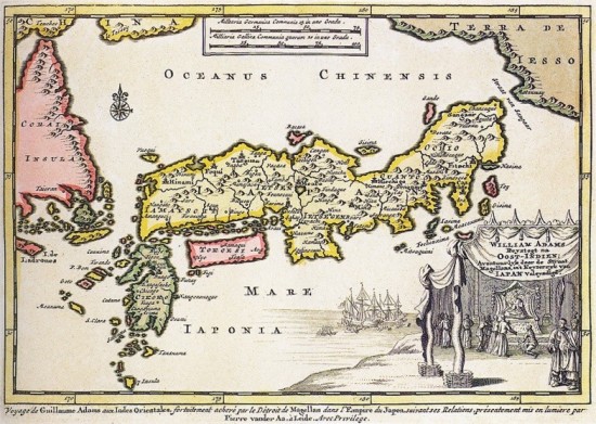
Ok, not exactly Japan itself, but a Western map (possibly French) from 1707.
I found it on Wikipedia while looking for information about another topic that I’ll talk about soon (there’s a big clue on the map itself for people who know the history of Japan well)
You’ll notice that even then, Shikoku was not deemed important (merely a rectangle).
Actually, one can see that the cartographer got things mixed up. Shikoku is called something like “Tokoesi” and that almost sounds like “Tsukushi“, that is one of Kyūshū‘s old names. Meanwhile, Kyūshū is called “Cikoko“, which is obviously a bad transcription of “Shikoku”.
Despite the embarrassing shape and the wrong name, one can notice that the cartographer got Shikoku‘s provinces right:
- Sanuki (“Sannaqui” on the map), i.e. Kagawa.
- Awa (I can’t really read on the map, but it’s something like “Av…“), that is Tokushima.
- Tosa (“Teasa“?), Kōchi.
- Iyo (“Viyo“), known today as Ehime.


Poor Shikoku! it has always been left out
Exactly.
As a hardcore sailor I collect old maps and charts. This is an awesome one David.
Thanks. Yeah, I love old maps too. I should look for more on the web (and of course post them here).
Very cool, I love old maps and would love to have a few framed up around my house! Thanks for the post
I do have a few, but for some reason, none of Japan yet (isn’t it strange that I never thought of looking for old Japan maps before, as I love old maps – and new ones too).